

AmericaGen Study Group
Chapter 19 Homework
Marceline Beem
Reference: Greenwood, Val D. “Government Land: Colonial and American.” In The Researcher’s Guide to American Genealogy, 4th ed., 469-494. Baltimore: Genealogical Publishing, 2017.
In Chapters 19 and 20, Val Greenwood discusses land records, focusing on government-issued land distribution and local land records, respectively. The author delves into how the federal and state governments acquired and distributed land. The metes and bounds system was used in colonial states and continued in those areas after the Revolutionary War. In the early 1800s, the government developed the township system, which was used in Florida.
My first extensive use of land records was in colonial l North Carolina, so I'm used to the metes and bounds system. I can visualize the line going from the black oak thence to the white pine thence to the stake better than I can the southwest quarter section of the northwest blah blah blah. Hence, one of my favorite resources for government-issued land records is HistoryGeo.com. It is a subscription site but well worth the investment if you have ancestors that lived in states using the township system.
The site holds two distinct record groups, its Antique Maps Collection and the First Landowners Project. I use the First Landowners Project extensively in my research. As the name implies, the First Landowners Project is a map collection of original landowners. It currently contains records for 21 states and is fully indexed. The maps show boundary lines and neighbors, making it easy to visualize where the land was and establish a FAN club.
When you log into the site, you'll be asked to choose the Antique Maps Collection or the First Landowners Project. After making your choice, If you aren't a current subscriber, you'll receive a prompt to subscribe. You can purchase subscriptions in 3, 6, or 12-month increments. After making payment, you can return to the selection screen and select First Landowners Project.
 |
| HistoryGeo.com |
The first screen is a map of the United States and instructions on how to use the site. I want to look for Sikes in Putnam County, Florida, so I put those terms into the search form.
 |
| Search Form |
At first the search function loads the results map showing the entire country, but then automatically zooms in on the specified county. The circled numbers tell me how many records there are in that section. I can zoom in to see more details.
 |
| Search results for the Sikes surname in Putnam County, Florida |
The green number two is about where where my family lived, so I zoomed in on that to view the map in closer detail. Now I can see the landowner's name and the date he received the land. The maps show all of the township, range and section numbers. The purchase boundaries are overlaid on a map with modern-day features, making it super easy to picture where the land is, especially if you are familiar with the area being studied. The maps also show the neighbors, which should be added to the owner's FAN club.
 |
| Zoomed in search results |
The two landowners are Crawford Sikes and Thomas Sikes, brothers to my great-great-grandfather, Andrew. Clicking on the little green figure representing Crawford's land, I get a pop-up with information about the land sale.
 |
| Search result with details of land purchase |
There's even links to view the record on the BLM website. Click on "View BLM Document" to view the patent and other record details.
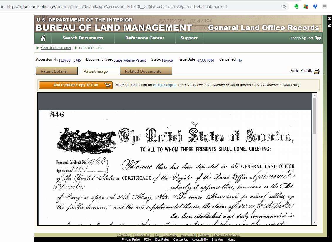 |
| Related records at the BLM website |
Back at HistoryGeo, I can zoom in even further to see what modern-day street Crawford's land was on. I recently delivered some packages near this area, and even today it's back on long, hard-to-drive-on dirt roads. I'll eventually go down to see the area, but it will have to be during dry season so I don't get my little car stuck in the muck!
 |
| Map of Crawford's land, zoomed in to see modern roads |
Thomas' land, however, is right off a main highway that I drive frequently. In fact, looking at the map, the highway runs through the southeast corner of his property, so I've been on it many times without knowing it belonged to a relative in the 1880s.
 |
| Thomas' Sikes land |
I love land records but using them to find property locations can be intimidating. Learning how to use readily-available resources, both free and subscription-based, are well worth it to make best use of research time and money. Whether you start your search at HistoryGeo or BLM, using these sites together can provide a lot of information in our research.
No comments:
Post a Comment